Overview of the new Joomla module from StarTech
Visualizing geographic data and zones of influence is a common task for corporate websites, online stores, and distribution companies. Introducing a new professional module for Joomla—Ireland Sales Territory Map. This interactive solution unifies the management of sales representatives, business territories, and tourist locations.
The module combines a clean, minimalist design, high performance, and complete autonomy.
Module Functionality
1. Interactive Territory Zoning (Sales Territory)
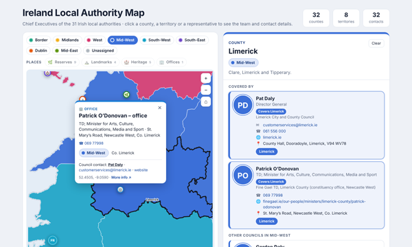
The map is divided into administrative districts (counties). By clicking on a specific region, territory, or employee name, the system instantly pulls up the team card and current contact information.
Visual: Sales representatives' primary regions are marked with round avatars, and dynamic dotted lines show the entire coverage area of a specific manager.
2. Places of Interest Management
The module handles the display of objects on the map perfectly—whether sales offices, warehouses, nature reserves, or historical landmarks (the demo version includes the Burren National Park, Cliffs of Moher, and Newgrange). Elements are automatically grouped into a convenient text directory below the map.
3. Full management from the Joomla admin panel
No coding or manual editing of configuration files. Lists of people, trade zones, and landmarks are fully editable through the admin panel:
• Team Manager: Add employees, upload their photos, provide contact information, and assign them to counties.
• Location Catalog: Manage points of interest, assign them categories (landmark, reserve, heritage), add descriptions, and external links.
4. Dynamic Import (Drag-and-Drop)
A unique feature of the module is its support for external location files. If a user or manager needs to quickly display their pool of objects on a map, simply upload a simple .txt text file with coordinates (for example, copied from Google Maps). The module will instantly process it and display the new markers, and the browser will remember these settings for a specific user.
Technical Benefits and UX
• Ease and Optimization: Vector county boundaries of the Republic of Ireland (based on official data from OrdnanceSurvey Ireland) have been optimized and simplified. The map doesn't overload the page and works smoothly even on mobile devices.
• Perfect UX: Familiar controls are supported—zooming with the mouse wheel or pinch-zoom on smartphones, dragging the map, and quickly resetting the selected region by pressing the Esc key.
• Privacy and Security: The extension fully supports modern cookie standards and integrates with Google Analytics/AdWords, allowing for flexible user consent policies.
What tasks is this module suitable for?
- B2B companies and distributors: for clearly displaying the responsibilities of sales agents, regional dealers, or franchisees.
- Tourism portals: for creating interactive guides, maps of attractions, routes, and protected areas.
- Logistics and retail networks: for displaying delivery coverage, branch locations, and pickup points or retail stores.
Ireland Sales Territory Map from StarTech is a ready-made tool that solves the complex task of geo-visualization using standard Joomla tools, giving the administrator full control over content out of the box.